
Taking accurate land survey records is an important part of any construction project. They provide vital information about the site and can act as a legal document if there are disputes over boundaries or other issues. However, mistakes can be made if you’re not careful — this article will discuss five common errors to help ensure your land survey is accurate and secure.

Introduction
When taking land survey records, people make several common mistakes. These include incorrectly measuring the property, not considering the earth’s curvature, and not using the correct datum. Inaccurate measurements can lead to serious problems down the line, so it’s important to be aware of these potential mistakes and how to avoid them.
What is a Land Survey Record?
A land survey record is an official document that shows the legal boundaries of a piece of property. A licensed surveyor usually prepares it. The record should include the following:
- A description of the property, as well as any easements.
- Rights of way.
- Other encumbrances may exist.
A land survey record is an important tool for buyers and sellers of property. It can help avoid disputes over the property’s boundary lines and can be used to determine its value for tax or insurance purposes.
What is Land Survey Number?
When looking at land survey records, one of the things you notice is the land survey number. This number can be used to identify a specific property, and it’s important to understand what it is and how it’s used. The government assigns the land survey number to a specific parcel of land.
It’s generally used for tax and ownership purposes. For example, the number can be used to locate the property on a map, and it can also be used to look up information about the property in public records.
If you’re looking at land survey records, make sure you know what the land survey number means. It can be a helpful tool in understanding a property, but it’s also important to know what other information is needed to ensure you have the complete picture.
Do you know Common Mistakes When Taking Land Survey Records? Let PropertyOk answer this question of yours!
Common Mistake #1: Not Knowing Your Geographical Area

When taking land survey records, one of the most common mistakes is not knowing your geographical area. This can lead to incorrect measurements and even legal problems if you must be more careful.
To avoid this mistake, familiarize yourself with the area you’ll be surveying before starting work. This means learning about the local terrain, climate, and other relevant factors that could affect your survey. You can then begin taking accurate measurements once you understand the area well.
Common Mistake #2: Not Knowing What You’re Surveying
When taking land survey records, one of the most common mistakes is not knowing what you’re surveying. This can lead to several problems, including inaccurate measurements, incorrect data, and even legal issues.
To avoid this mistake, it’s important to understand what you’re surveying before you begin clearly. This means knowing the property boundaries, terrain type, potential obstacles, and anything else that could impact your survey. Once you have this information, you can be sure that your survey is accurate and complete.
Common Mistake #3: Not Maintaining Proper Documentation
One of the most common mistakes when taking land survey records is needing to document the work properly. This can lead to serious problems, as it can be difficult to prove what was done without a record. Instead, take photos or videos of the work, and keep detailed notes. This will save you a lot of headaches.
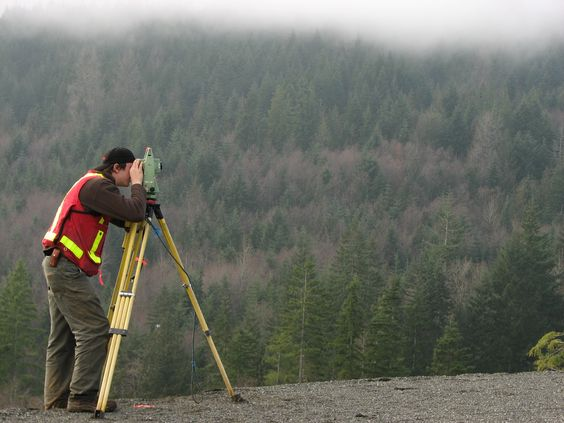
Common Mistake #4: Not Calibrating Your Equipment
One of the most common mistakes when taking land survey records is failing to calibrate your equipment. This can lead to inaccurate measurements and data, which can, in turn, lead to costly errors in your survey.
To avoid this mistake, calibrate your equipment before each use. Check the manufacturer’s instructions for specific calibration procedures. For example, when measuring distances, you must ensure your instrument is set to the correct units (feet or meters).
Calibrating your equipment may seem like an extra step, but it is essential for ensuring accurate survey data. In the long run, this will save you time and money.
Common Mistake #5: Ignoring Local Regulations and Requirements
When taking land survey records, it’s important to know local regulations and requirements. Ignoring these can lead to problems, such as delays in getting your project approved or fines.
Before starting your project, check with your local planning department for any special requirements. Please do so to avoid costly delays or other issues.
If you are interested in buying a property in Mumbai, please do not hesitate to contact us for assistance.
Check Your Land Details Online
If you’re looking to purchase land, it’s important to do your due diligence and check the land details online before making any decisions. You can save time, money, and headaches by avoiding these common mistakes when taking land survey records.
One common mistake is not checking for easements. Easements are rights that someone has to use your property for a specific purpose, such as a utility company having an easement to run power lines through your land. Knowing what an easement is on the property you are considering buying and how it will affect land use is important.
Another mistake is assuming that all property lines shown on a map are accurate. Just because a line is drawn on a map doesn’t mean it’s correct. It’s always best to have a professional surveyor come out and mark the property lines, so everything is clear later on.
Another common mistake is not getting a certified survey. A certified survey shows the property boundaries and any structures or improvements on the land.
This is important information to have when you’re buying land so that you know exactly what you’re getting. Finally, one last mistake people make is not knowing who owns the mineral rights to the land they’re buying. If you’re planning on developing the land or drilling for oil or gas, it’s important to know who owns
Issues with keeping land records
Several issues can arise when keeping land survey records. First, if the records are properly maintained, they can be accurate. This can lead to disputes between landowners and Surveyors, which can be costly and time-consuming. If records are lost or destroyed, it cannot be easy to recreate them. Finally, records must be kept up-to-date to reflect changes in the land.
Conclusion
Taking land survey records can be challenging. However, you can ensure accurate and reliable measurements with the right preparation and knowledge. By following this guide, you can confidently complete any project.
Read more: HOW TO BUY A FLAT-HERE’S WHAT YOU NEED TO KNOW.
FAQs
1. Are land surveys public record?
Land surveys are often considered public records and can typically be obtained from the county or city government office where the property is located.
2. where to find land survey records?
Some places also have online databases to search for land survey records.
3. Can you look up a survey online?
Depending on the location and availability, it may be possible to look up a survey online through a county or city government website or a private land records service.
4. Why are land surveys important?
Land surveys are important for various reasons, including determining property boundaries, resolving disputes over property lines, and ensuring that buildings and structures are built in the correct location. They are also required for many legal transactions, such as buying or selling property and obtaining building permits.

 Thank You